

Introduction
In the “12-Day War,” which began on 13 June 2025, Iran’s nuclear facilities were among the primary targets. The strikes against deeply buried facilities on 22 June 2025 employed the US military’s most powerful bunker-buster munition, the GBU-57 Massive Ordnance Penetrator (MOP), which attracted significant media attention for its reported penetration capability. According to official statements issued in June and July 2025 by the Central Intelligence Agency (CIA, 2025), the International Atomic Energy Agency (IAEA, 2025a), and the US Department of Defense (DoD, 2025a), several Iranian nuclear facilities were severely damaged. However, no detailed technical assessment has been made public regarding the extent of damage to individual facilities. This is particularly true for the Fordow fuel enrichment plant (FFEP), regarded as the principal target of the strikes and believed to be Iran’s deepest underground nuclear facility. The plant is estimated to lie approximately 80–90 metres (260–300 feet) below the surface. Although this figure has circulated since press reports appeared in 2011–2012 without official confirmation (Albright et al., 2022), it exceeds the widely cited penetration capability of the MOP.
Subsequent media reports published high-resolution commercial satellite images showing surface-level damage at the suspected impact site. While these images provided insight into surface conditions, they revealed little about what occurred underground. Since then, speculation has proliferated, often reflecting the political and strategic interests of Israel, the United States, or Iran rather than independently verifiable facts. Questions regarding whether the destruction of the principal nuclear facilities had in fact been achieved continued to surface in the period surrounding the 2026 US and Israeli attacks on Iran. Given the scarcity of objective data on operational outcomes, this episode highlighted the challenges faced by the media in independently verifying claims about strike effectiveness.
On the other hand, the location of the strike site itself can be identified with relative confidence through open-source methods, including visual comparison of satellite imagery with publicly available mapping tools. Moreover, Iran is situated largely within the Alpine–Himalayan orogenic belt, a tectonically complex region formed by the collision of the Arabian and Eurasian plates. Decades of geological research and resource exploration have produced a substantial body of publicly available geoscientific data on the region’s subsurface conditions.
From the perspective of geojournalism—defined as “the practice of telling stories with data generate [sic] by the earth sciences” (Geojournalism.org, n.d.)—this article examines how far open-source geoscientific information can take us in assessing the likely effectiveness of the GBU-57 strike against the Fordow facility. It also evaluates whether media reporting on the weapon’s penetration capability accurately reflected the underlying physical constraints.
Prior research and research gap
Among prior studies that have undertaken geological analysis under conditions precluding direct site access, Coblentz and Pabian (2013, 2015) provide a notable example. Working with detailed geological maps produced by Japanese geologists during field surveys in the 1920s and 1930s, combined with modern satellite imagery to identify rock types through drainage patterns and topographic analysis, they characterised the geology of North Korea’s Punggye-ri nuclear test site. Given the absence of large-scale, high-resolution geological maps of North Korea—and the near-zero prospect of obtaining them for an area as sensitive as a nuclear test site, where only small-scale maps at 1:500,000–1:1,000,000 are publicly available—their approach involved cross-referencing historical geological maps with satellite imagery to characterise the three-dimensional (3D) geological properties of a site accessible to none but a limited circle of North Korean military personnel.
Building on the site characterisation by Coblentz and Pabian (2013, 2015), Sasazawa (2022) conducted a site assessment covering all six nuclear tests, including three conducted since 2016, drawing on location data and related information published by the Preparatory Commission for the Comprehensive Nuclear-Test-Ban Treaty Organization (CTBTO, n.d.). These examples demonstrate that analysis of site-specific geological characteristics using historical geological maps and accessible geospatial information—although limited in number—in fact has been carried out and has yielded useful data—for example, the finding that test tunnels at Punggye-ri were relocated after the first test to rock of higher containment integrity (Coblentz and Pabian, 2015).
Nevertheless, geological analysis of sites of high military interest, even when conducted, tends to remain classified and is rarely made available to the public. While journalism and independent think tanks do on occasion analyse the destruction of surface facilities using commercial satellite imagery, subsurface conditions rarely attract comparable attention; the scarcity of geoscience expertise in these communities means that geological analysis is seldom pursued in any systematic way.
The same applies to Iran. Even the IAEA (2025b) has confined itself, in its Board of Governors and General Conference reports, to assessing compliance with the Joint Comprehensive Plan of Action (JCPOA) on the basis of surface facility activity derived from satellite imagery.
Responses to the outcome of the 12-Day War followed a similar pattern. Yet, as the following analysis demonstrates, both detailed geological maps and accessible geospatial information exist for the region in question. Moreover, a case such as this is precisely where site characterisation analysis is most fundamentally needed. No investigation—before or after the strikes—has examined how the local geology and its mechanical strength bear on the MOP’s penetration performance at this site. This represents a significant gap in publicly available information with the potential to shape international opinion.
At the same time, there has been a growing emphasis on fact-checking and verification in journalism using publicly available data. In Europe, organisations such as Bellingcat and Forensic Architecture have applied open source intelligence (OSINT) methodologies, including photo forensics and photogrammetry, to investigate misinformation and human rights violations in conflict settings. However, in the case of the Fordow strikes, although satellite imagery has been widely used to assess surface damage, verification that systematically incorporates site-specific geoscientific conditions remained limited. To the author’s knowledge, no prior study has applied a geoscientific site analysis to this case. In this sense, the present study represents an exploratory attempt to incorporate geoscientific considerations into OSINT-based verification.
Methodology and results
This study draws on detailed publicly available geoscientific data to assess the geological conditions at the site, and on commercial geospatial services and post-strike satellite imagery to determine the location of the FFEP. The selection of data sources was guided by their availability, spatial relevance to the site, and prior use in comparable geological or OSINT-based analyses.
In addition, commercial article databases were used to collect original reporting published before and after the 12-Day War from media in European languages and Japanese, which formed the basis for the verification of media coverage.
Details of the methodology and the results obtained are presented in the following sections.
Can the location of the Fordow facility be identified?
Neither Iranian nor US authorities have officially disclosed the precise coordinates of the FFEP site. Nevertheless, high-resolution satellite imagery (Figure 1) captured by commercial providers, such as Vantor (formerly Maxar Technologies), has been published by media outlets, military think tanks and photo stock sites following the strike.
Figure 1
Commercial satellite imagery of the Fordow Fuel Enrichment Plant collected on 22 June 2025, showing several large craters across the ridge and a wide area covered in grey-blue dust. © 2025 Maxar Technologies.
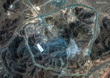
By comparing the shape of road, ridge lines, a few ground facilities and other topographic features visible in the images with publicly available digital maps, such as Google Maps, the strike location, i.e. the facility’s location, can be inferred with reasonable confidence. The author independently confirmed it using commercially acquired Maxar imagery. This confirmation places the facility approximately 30 km north-northeast of the centre of Qom, at roughly 34.885°N, 50.999°E (truncated to 3 decimal places). The correspondence between satellite imagery and Google Maps is clear. The facility is also identifiable on Google Maps, where it appears with a location marker.
It is also worth noting that while Western media have generally referred to the site as “Fordow,” the town of Fordow itself lies south of Qom. The enrichment plant commonly labelled as Fordow is therefore more accurately described as being located north of Qom rather than at Fordow proper.
Geological setting of the target area
Geologically, the Qom area is situated within a northwest–southeast-trending tectonic zone affected by the Alpine-Himalayan orogeny. This region includes the Urumieh–Dokhtar magmatic arc (UDMA), characterised by magmatic intrusions, and adjacent sedimentary basins with carbonate sequences.
More specifically, the area surrounding FFEP lies in the Saveh–Qom area within the Western part of the Central Domain (also known as the Central Basin). The local stratigraphy consists primarily of the Qom Formation—dominated by carbonate rocks, such as marl—along with the overlying and underlying Upper and Lower Red Formations, which consist mainly of hematitic reddish sandstone and siltstone. These units were deposited during the Oligocene to Neogene. To the west, Eocene igneous rocks associated with the UDMA are also distributed (Morley et al., 2009).
Igneous rocks, such as plutonic and volcanic rocks, are generally classified as hard rocks. By contrast, sedimentary rocks, including limy fine-grained carbonate like marl, exhibit a wide range of mechanical properties depending on age, cementation, compaction, diagenesis, and weathering.
How deep could the GBU-57 penetrate?
The US Air Force (n.d.) describes the GBU-57 (MOP) as “approximately 20.5 feet long, with a 31.5-inch diameter and a total weight of slightly less than 30,000 pounds. The weapon will carry over 5,300 pounds of explosive material [...]. It is designed to penetrate up to 200 feet underground before exploding.”
According to the US Congressional Record (2005, p. S8727), Senator Feinstein cited the manufacturer’s description of the MOP, which was then under development: “It can burrow 60 metres in the ground through 5,000 psi—pounds per square inch—of reinforced concrete. It will burrow 8 metres into the ground through 10,000 psi reinforced concrete.”
This appears to be the earliest readily accessible official public reference to these material-specific penetration figures.
Military-information websites and think tanks, including GlobalSecurity.org (n.d.), have repeated the same penetration figures—typically 60 metres (200 feet) through 5,000 psi and 8 metres (25 feet) through 10,000 psi reinforced concrete—without identifying their underlying technical source. Although the figures date from the weapon’s development phase and its actual performance remains officially undisclosed, 60 metres (200 feet) is an extraordinary claim compared with the reported performance of earlier penetrators.
According to Coe and Schmitt (1997), the 5,000-pound-class GBU-28, the next largest penetrator below the GBU-57, “has the ability to penetrate 20 feet of concrete or 100 feet of dirt.” No strength values, such as compressive strength in psi, are specified for either material. The US Air Force Hill Air Force Base (2007) and the National Research Council (2005) report that 2,000-pound-class penetrators, such as BLU-109 and BLU-116, can penetrate approximately 6 feet to more than 12 feet of reinforced concrete.
The GBU-57 weighs approximately six to fifteen times as much as these weapons, but penetration does not scale linearly with mass. Higher impact velocity can increase penetration, but the strength of a penetrator casing limits the impact velocity it can survive. Nelson (2002) argued that even a penetrator made from the strongest steel would limit “the maximum possible penetration depth into reinforced concrete to about four times the missile length.”
Moreover, if Feinstein’s statement is taken at face value, the 60 metres (200 feet) figure was conditional from the development phase on a target compressive strength of 5,000 psi.
GlobalSecurity.org (n.d.) itself cautions that the figures seem suspiciously high and may in fact be first in feet, not metres. No evidence substantiating this proposed explanation has been identified. It should be emphasised, however, that such assessments have not been peer-reviewed, are not based on Iran’s site-specific geology, and depend on the unverified assumption that metres and feet were confused.
Target geology and resistance to penetration
From the outset, it has been widely assumed that underground facilities constructed in the Middle East are protected by high-strength concrete, and the US military design requirements for the weapon appear to reflect this assumption. However, the mechanical properties of natural rock differ significantly from those of reinforced concrete. Generally speaking, igneous rocks, such as granite, exhibit uniaxial compressive strengths ranging from the tens of thousands of psi, while typical Cenozoic sedimentary rocks, such as sandstones and carbonate rocks, range from several thousand to over ten thousand psi. Concrete is not inherently harder than natural earth or rock; the relevant variable is the strength of the target material.
Two recent studies provided relevant empirical data for central Iran. Amiri et al. (2024) analysed 58 sandstone samples from the Upper Red Formation collected approximately 100 kilometres southeast of the FFEP site (Figure 2) and reported a mean uniaxial compressive strength (UCS) of 10,270 ± 5,593 psi (70.81 ± 38.56 MPa). Jalali et al. (2017) examined 106 samples of wackestone, mudstone, boundstone, grainstone, marl, and gypsum collected from the Qom Formation about 35 kilometres southwest of the facility (Figure 2), finding UCS values ranging from 900 psi (6.21 MPa) to 23,252 psi (160.32 MPa), with an average of 9,963 psi (68.69 MPa).
Figure 2
Geology of the Qom area and rock sampling locations. × marks the sampling point of Amiri et al. (2024); ● marks the sampling area of Jalali et al. (2017). FFEP: Fordow Fuel Enrichment Plant; UDMA: Urumieh–Dokhtar Magmatic Arc.
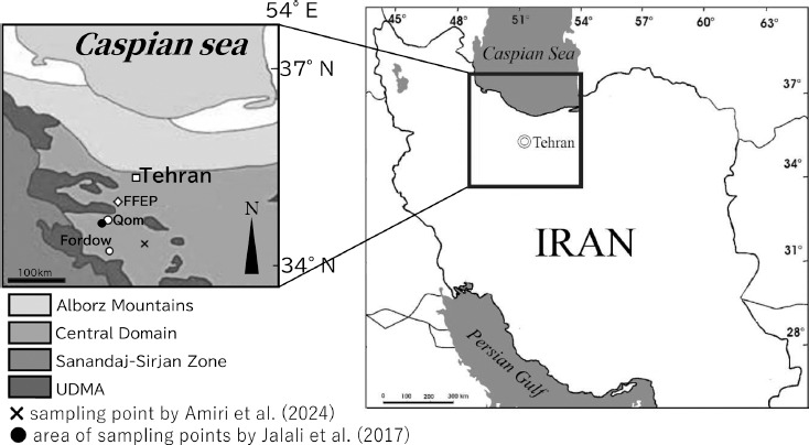
Rock strength may vary among individual beds within a formation. However, penetration is governed by the sequence of beds encountered along the penetration path; even where weaker beds are present, inter-bedded high-strength layers may substantially constrain penetration and reduce the significance of isolated low-strength samples. Nonetheless, the close agreement between the mean values reported in these two independent studies suggests that compressive strengths on the order of 10,000 psi may be representative of the regional geological conditions. If Iranian engineers selected particularly competent rock for the construction of the facility—as would be expected—the penetration depth achievable by the GBU-57 could plausibly fall well short of the widely cited 200-foot figure and, in some geological scenarios, may approach or even fall below the lower bound of its reported performance envelope.
Post-strike debris is visible in the imagery. Analogue data on unconsolidated regolith, with bearing strengths of only several to about 75 psi (Sperling, 1970; Zacny et al., 2012), suggest that such material would add only marginal resistance to subsequent strikes, compared with bedrock of 10,000 psi, although its contribution is unlikely to be zero.
Verification of media reporting
In European-language media coverage obtained through LexisNexis news search, twenty original articles published between October 2024 and September 2025 cited penetration depths of 60 metres or 200 feet. Among these, the Associated Press (Rising, 2025, 22 June) described the weapon as penetrating “about 200 feet (61 metres) below the surface before exploding,” with subscriber outlets repeating this verbatim and numerous other print and online media adopting similar phrasing.
The New York Times (Ismay, 2024, 17 October) reported the weapon as capable of penetrating “up to 200 feet underground before exploding,” and The Daily Telegraph (Blomfield, 2025, 23 June, pp. 2–3) described it as boring “through up to 200 feet of rock,” both adding a sense of maximum capacity to their coverage. Some outlets also used formulations such as “over 200 feet” or “more than 200 feet.”
The Irish Times (2025, 23 June, p. 7) made no reference to specific penetration depths but noted that the figures were based on reinforced concrete resistant to 5,000 psi. BBC Afrique (Mackintosh, 2025, 23 June) introduced some range into its reporting, citing the weapon as capable of penetrating approximately 18 metres (60 feet) of concrete or 61 metre (200 feet) of soil before detonating. With respect to concrete, this estimate is consistent with the hypothesis that feet and metres were confused. The most detailed specifications appeared in a supplemental box in Irish Daily Mail (Nicol, 2025, 23 June, pp. 4–5), which listed 200 feet (61 metres) of high-strength concrete, 26 feet (8 metres) of extreme-strength concrete, and 131 feet (40 metres) of moderately hard rock. None of these accounts, however, attempted to verify such figures against the actual geological conditions at the site.
A similar pattern appeared in Japanese media coverage. Over a comparable period, a search of G-Search and Nikkei Telecom, two comprehensive Japanese databases of newspaper and broadcast content, identified 47 articles describing the GBU-57 as capable of penetrating 60 metres (200 feet) “underground,” “below the surface,” or “into the ground” (author’s translations). None of these accounts noted that this figure applies to 5,000 psi reinforced concrete, nor that actual penetration depth in natural rock could be considerably lower. Exceptionally, Nikkei (Awashima et al., 2025, 23 June) reported that it depended on the hardness of the ground. Of the 47 articles identified, only a handful noted that 60 metres (200 feet) represents a maximum capacity.
Across all the media reports examined, no report verified the consistency of these claims with actual geological conditions using publicly available scientific data. Although some independent online media reports mentioned a carbonate-dominant geology (e.g. Gillard, 2025), these references describe broad regional trends rather than site-specific conditions. As described above, the surface geology of the Qom area is dominated not only by the Qom Formation but also by the Upper Red Formation. Consequently, limestone and marl do not always cover the surface around the FFEP site.
Discussion
The analysis presented here represents a geojournalistic assessment of underground penetration based entirely on publicly available information. Its purpose is not to criticise any government’s claims of success, but rather to demonstrate the extent to which open-source geoscientific data can inform independent evaluation.
Scenarios and assessment of strike effectiveness
The MOP strike may have penetrated and disrupted the bedrock at the FFEP site to a depth on the order of 8 metres (25 feet). Even assuming that the “double tap” strikes (Landay, 2025)—an initial six MOPs followed by six more—were executed with precision, the combined penetration depth of the first and second strikes may have remained insufficient to reach facilities located at depths of approximately 80–90 metres (260–300 feet), making direct structural destruction unlikely.
If substantial internal damage, such as the collapse of underground chambers, did occur, this would more plausibly be attributed not solely to the penetration capability of the MOP itself but to pre-existing structural weaknesses within the rock mass. These may include naturally developed fractures formed over geological timescales, or previously unmapped minor faults potentially associated with known fault systems within the Central Domain (Morley et al., 2009). Such features could have been further propagated or activated by the vibrational effects of the strikes.
Although Jalali et al. (2017) indicate that parts of the Qom Formation include relatively weak material, it is unlikely that the specific site selected for the facility would deviate significantly from regional averages in a manner that would substantially facilitate large-scale structural collapse. The construction of underground facilities in competent rock is intended not only to reduce detectability from satellite observation but also to exploit the protective properties of the surrounding geological barrier against aerial bombardment.
As noted in the statement by Grossi (IAEA, 2025a), “Given [...] the extreme vibration-sensitive nature of centrifuges, very significant damage is expected to have occurred.” Even in the absence of complete structural collapse, it is therefore plausible that the strikes produced a degree of functional disruption.
At the same time, commercial satellite imagery acquired by Maxar Technologies on 19 June 2025 and 20 June 2025, immediately prior to the strikes, recorded what was described as “unusual activity [...] with a long line of vehicles waiting outside an entrance of the facility” (Landay, 2025). While the nature of this activity remains uncertain, it could have contributed to the preservation of uranium-enrichment capabilities. If the underground chambers of the FFEP remain structurally intact, the possibility of their reuse for a range of future operations cannot be excluded.
The strikes may also have provided the Iranian side with empirical information regarding the penetration performance of the MOP under specific geological conditions. Iran, situated within the Alpine–Himalayan orogenic belt and characterised by widespread hard rock formations, has historically relied on underground construction for military and nuclear infrastructure. The observed outcomes of this strike may therefore inform future site selection and design strategies for underground facilities.
It is possible that the US planners fully accounted for the challenging geological conditions described above. If so, this can explain why the US double tap strikes appear to have focused on existing openings—most notably the ventilation shafts described at the Pentagon briefing (DoD, 2025b)—rather than attempting to directly collapse the deepest chambers. Moreover, any such assessment necessarily remains provisional; definitive conclusions about the actual extent of underground damage will require the eventual release of classified information or on-site inspection.
The role of the media
What can be evaluated with greater confidence is the quality of media reporting. News coverage understandably prioritises speed, and a certain degree of simplification is inevitable. As the media survey described above demonstrates, however, many outlets repeatedly cited the figure of “60 metres” or “200 feet” of penetration, without clarifying the material and strength conditions underlying that figure. Without that qualification, the reporting does not permit an assessment of whether the Iranian rock is stronger than the cited reference material.
More generally, the uncritical circulation of numerical claims in media reporting can hinder accurate military analysis, distort diplomatic decision-making, and influence public opinion in unintended ways. It may also contribute to the exaggeration of one side’s capabilities beyond their actual limits, thereby creating opportunities for exploitation in information warfare and propaganda.
In this context, it is worth asking whether the widespread repetition of the “200-foot” figure had any influence on political decision-making or international dynamics in the various phases leading up to early 2026. If the underlying assumptions of this figure had been more widely understood, different responses might have emerged in some contexts.
It is therefore evident that independent actors, including those in journalism, have a responsibility to present objective data and to critically examine the basis of frequently cited numerical claims. Continuous efforts at fact-checking and verification are essential, particularly when such figures have the potential to shape broader strategic and political perceptions.
Conclusions
Even without advanced modelling or classified data, a considerable degree of technical scrutiny is possible using publicly available geoscientific information. Such analysis suggests that the widely repeated figure of “200 feet” of penetration should not be treated as a universally applicable measure of bunker-buster effectiveness.
In an era of heightened media literacy and increasing reliance on OSINT and artificial intelligence (AI)-assisted analysis, numerical claims should be accompanied by clear explanations of their underlying assumptions. From a geojournalistic perspective, reporting that emphasises maximum figures without context risks misleading audiences and undermining credibility—particularly when geological conditions are likely to impose far more stringent constraints than those implied by simplified metrics.