
Introduction
The organisation of airstrips and the rules for operating flights thereon in peacetime are dictated by strictly defined provisions compliant with the ICAO regulations1.
While performing wartime operations (both by air forces operating combat flights and civil aviation operating contractor flights e.g. supply and transport flights), these rules may differ depending on the region and the nature of operations or the airfield (airstrip) infrastructure (Kozuba and Krawczyk, 2018). Therefore, the practical purpose of this publication is to diagnose the method of the organisation of flights and the rules for operating them, as well as the infrastructure of an airstrip operating in wartime conditions. The aim here is to eliminate errors from the tasks performed by the Air Traffic Services personnel teams (Read and Charles, 2018). The theoretical purpose of the article is to attempt to find the answer to the following question: How do airstrips and air traffic military staff function in wartime? The research problem has led to an attempt to provide an answer in the form of the following working hypothesis: Diverse conditions of creating airstrips for Military Contingents result in a non-homogeneous working environment for the Air Forces of the Republic of Poland. It is assumed that the diverse and non-uniform methods of organisation of airstrips in mission areas cause difficulties in the handling of such airfields by the military air traffic staff and the ground supporting personnel.
To answer the above question and verify the hypothesis, a focused method was applied, followed by an ex post facto experiment, a study of the relevant literature, observations and a survey conducted among the personnel subject to the research2.
Background of the military operations in Afghanistan
The main cause of waging the war on terrorism in Afghanistan was the tragic events of 11 September 2001. The military objective, i.e. defeating the Taliban, was achieved as early as 2002. This is when the stabilisation operation was commenced under the auspices of the International Security Assistance Force (ISAF). Operating within ISAF, the NATO forces carried out their tasks in conformity with the United Nations Security Council Resolution no. 1386 of 20 December 2002, Resolution no. 1510 of 13 October 2003 and the Bonn Agreement of 5 December 2001 on Provisional Arrangements in Afghanistan Pending the Re-Establishment of Permanent Government Institutions. The main objective of the ISAF missions was to support the Afghan government in providing and maintaining security, as well as assistance in rebuilding Afghanistan and creating the structures of a democratic state. Approximately 35 thousand soldiers from 37 countries took part in the missions. ISAF’s non-military tasks were aimed at improving the country’s economic situation, increasing the acceptance of the democratically elected government by society, and boosting international cooperation. Their objective was also to convince the Afghan people that a peaceful development of their state was possible, in the long term. Widely understood development consists not only in rebuilding damaged buildings or providing humanitarian aid but also in restoring the organisational structures of a state. One of the priorities of the ISAF mission was to restore the functioning of all means of transportation, including air transportation (Jahangoshai Rezaee and Yousefi, 2018). Polish controllers in Afghanistan therefore took part in securing air traffic at the Kabul Afghan International Airport (KAIA) and the military airfield in Ghazni.
Kabul Airport – KAIA
The Kabul Afghan International Airport (KAIA) is the main air transportation centre in Afghanistan. The first initiative was put forward in October 2003 calling for support and maintenance of the airport in a number of priority areas i.e. protection, security, infrastructure, and air traffic management. Over the next few years, a number of initiatives were taken, including the formation of the civilian air authority, provision of intensive training for air traffic controllers and flight crews, extension of the airport infrastructure etc.
Such extensive actions required significant financing and the support of a qualified international personnel. As a country actively participating in all activities of the international community, Poland also became involved in the process of developing Afghan aviation, especially by supporting the air traffic management process. In 2009, for the first time, Polish air traffic personnel, more specifically military personnel, carried out tasks related to the management of the Kabul airport (Grenda, 2014). On the KAIA mission, the soldiers rotated every six months under the command of one of the NATO states. Poland carried out the mandate tasks during the 5th shift of the Polish Military Contingent (PMC) in the Islamic State of Afghanistan between 5th March and 30th December 2009. On 1st April 2009, Poland took over the tasks at the KAIA airport from Hungary and concentrated on maintaining the permanent operational readiness of the airport, ensuring secure take-offs and landings at the airport, and smooth handling of passengers, cargo, and aircraft.
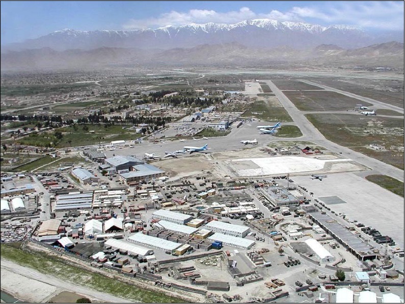
The Kabul Afghan International Airport is located 1 km from Kabul (Figure 1). It was built in 1970, but its operations had been affected by the unstable political and economic situation of the country. During the Taliban rule, the airport practically did not function due to the economic sanctions imposed on Afghanistan (Suau-sanchez and Voltes-dorta, 2019).
International operations were restored at the airport in 2001. It was initially used exclusively by the armed forces of the United States and NATO. In 2002, the economic sanctions were lifted and the airport was made available to civilian air traffic. The Kabul Afghan International Airport is administered by the Ministry of Transport and Civil Aviation of the Islamic State of Afghanistan. The Kabul airport, used jointly by ISAF and the national authorities of Afghanistan, was supervised directly by the ISAF Commander. The chief task of KAIA was to serve as the main reloading port for ISAF and to secure the take-offs and landings of civilian transport aircraft. Consequently, the commander of KAIA was in fact the civil authority of the airport. The most important element of the airport, i.e. the runway, was 3500 long and 45 wide. The airport had a complex system of taxiways and a number of aircraft aprons. The airport was conventionally divided into two functional areas. The southern part of the airport was used by civilians, and northern by the military. The airport featured a number of radio navigation devices (Papp, 2005):
ILS RWY 29 (cat. I) – a landing guidance system;
VOR/DME – a close and medium range angular radio navigation system;
PAR – a precision approach radar;
TACAN - a military close-range air navigation system;
Airfield Lighting System.
The following systems were used to secure air operations at the KAIA airport:
- DARIS Radar – an airport radar transponder system;
- ICN Communication System – a radio telecommunications system for communication with the personnel and vehicles operating at the airfield;
- ALDIS lamp – a system of signal lights used for coordinating the ground and air traffic in the event of no radiocommunications;
- TACMET - a meteorological observation system.
The Kabul International Airport operated in conformity with the Local Operating Procedures of the Kabul Afghan International Airport (LOP KAIA): “ATC Operating Procedures” for the Kabul Airport (version 17 of 12 June 2003) issued on 2 March 2004, and “Local Operating Procedures” of 10 March 2005, respectively. They regulate all material issues related to the functioning of the airport, the methods for carrying out and securing ground traffic operations as well as provide safety guidelines3. In addition, LOP contains procedural agreements related to the multinational operations carried out at the International Kabul Airport (KAIA).
The Ministry of Transport of the Afghan Government authorised the Allied Force Air Component Commander to designate an Airspace Control Centre as the authority responsible for the Flight Information Region (FIR). Air traffic management was agreed as follows: within the Airport Control Zone (CTR), the Airspace Control was managed by ISAF, while the Air Traffic Control was handled by air traffic control tower in Kabul. The KAIA Commander was responsible for managing the respective Air Traffic Control operations at the KAIA airport (NATO/ISAF, 2005b). The International Airport was part of the Polish Military Contingent (PMC) in Afghanistan but it reported to the ISAF Command in Kabul, and to PMC only within the national (reporting) and logistic system (as part of the national logistics component).
The Structure of the International Airport included 143 posts staffed by a few NATO states. The organisational structure of KAIA features four main functional divisions carrying out the following tasks (NATO/ISAF, 2005a):
Air operations – responsible for controlling and managing the air traffic of KAIA and coordination of the ground traffic operations of different organisational units. In addition, the air operations division is responsible for all functions related to the unloading operations at the airport.
Armed troops protection – responsible for protecting persons and property at the airport. It is also responsible for mine clearing of areas and facilities.
Logistics – secures accommodation, repairs, and maintenance of equipment, handles supplies, transport, and storage of MPS goods and products.
Staff – supports the KAIA commander in decision-making. It is responsible for managing and delegating personnel, analysing the intelligence situation, and organising the command and communications system. The Staff is also responsible for establishing and maintaining relations with the civil institutions and the Afghan people.
Poland took over the management of the military and civilian flight operations in the air and at the airport, coordination of the airspace traffic as well as the management of key structures of the staff and the support and security elements. Due to the nature of its tasks, the group included air traffic controllers, air engineering experts as well as Military Police soldiers, including sniffer dog handlers helping the Belgian subunits to protect the airport. Some of the posts were filled by Afghan personnel as part of the host-nation’s responsibilities (Grenda, 2014).
During the period in question, the air traffic controllers team secured over 56 thousand air operations4. The number of flights varied. The average number of flights carried out on a daily basis was 380; however, it should be stressed that most (97%) operations we carried out during the day. Consequently, the average number of operations per hour was 40-47, which meant that a take-off, landing or another aircraft-related operation was carried out every minute on average. Whilst carrying out the mandate operations, 164 situations were reported that compromised the safety of the air operations, including mainly:
- unauthorised intrusions into the manoeuvring area;
- air misses resulting from a failure to follow the airport control authority’s instructions;
- failures by air crews to observe the SLOT times (Androutsopoulos and Madas, 2019);
- bird strikes during take-off or approach;
- landings with a punctured main suspension tyre;
- landings with an engine failure;
- Fire Brigade vehicle collisions in the aircraft parking areas.
According to the Air Traffic Control Head at the KAIA airport, the main cause of the incidents was lack of English and the applicable regulations. Many problems resulted from the cooperation with the Afghani air authorities. Cultural differences, lack of English and aviation issues had a specific impact on the airport management process.
Ghazni airstrip
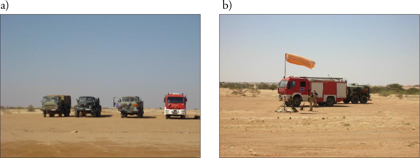
To date, few studes have investigated the characteristics of Ghazni airstrip used by Polish and allied aircraft during military operations. Previous studies have explored Afghan airfields and their role in supporting military operations. Reed (2009) investigated building of new airfields whereas Perry and Kassing (2015) and Day (2002) examined air and air-ground operations carried out in Afghanistan. Zajkowski and Bielawski (2016) analysed the airstrip located in the eastern part of the Ghazni province that was used by the Polish and allied air forces where the air traffic was managed and secured by Polish controllers. HLZ Ghazni (Helicopter Landing Zone) was 181 km south-east of Bagram. It consisted of two aprons (Figures 2 a and b). 2 a i b). The first one - HELI PAD5 – was situated in the central part of the base and featured a gravel-covered section, two concrete spots (CARGO PAX/MCT) 30x30 m and two smaller FARP points (Forward Arming and Refueling Points) adapted for refuelling and arming helicopters on the spot). This part of the airstrip could accommodate 6-8 helicopters with landing directions of 080°/260°. Additionally, two concrete surfaces situated in the south-western part of the Heli Pad, colloquially referred to as Old Medevac Parking, were used for helicopter parking (ATP-Ghazni, 2010).
Figure 2
HLZ Ghazni: a) View of runway RWY 17/35 and HELIPAD, b) aistrip plan The plan was prepared based on the Air Procedures Guide HLZ Ghazni (ATP-Ghazni, 2010)
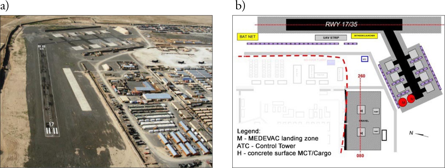
Located in the south-eastern part of the base, the other apron of the airstrip housed a runway (RWY) of 405x25m, suitable for take-offs and landings (of mainly Polish helicopters) at 35° or 170°, and 8 parking places with a concrete surface (mostly for Polish helicopters) of 25x25m, with a taxiway (TW) of 12 m in width, which also served as an emergency landing spot (Wrzosek, 2016).
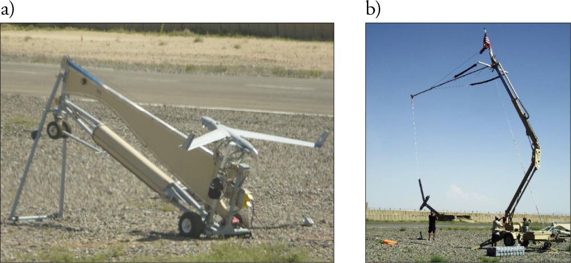
A new experience for the Military Air Traffic Service personnel was cooperation with different types of UAVs (Unmanned Aircraft Vehicles). The Ghazni landing zone was adapted for operations carried out by Polish and allied unmanned aircraft vehicles. For this purpose mainly, a concrete surface of ~197x16 m was used, colloquially referred to as the UAV Strip. At the southern extension of the UAV Strip were mobile pneumatic launchers (picture 3) and catchers (vertical line) - Sky-Hook (Figure 3b) (Adamski, 2014) or Scan Eagle unmanned aircraft vehicles. For the purposes of the next type of Aerostar UAV, the thresholds of runways RWY 35 and RWY 17 were fitted with permanent launch and landing systems (Bielawski, Rządkowski and Perz, 2018).
North of the threshold of RWY 17 were special nets, referred to as Bat Nets, used for the landing of the Northrop Grumman Bat, another unmanned aircraft vehicle.
The control tower (TWR) of the Military Airport was situated on a mobile Independent Command Post (ICP) – Figures 4a and b. Placed on the south-western side of RWY 17/35, it was used by the air traffic controllers to secure air operations on a continuous basis (shifts). The navigation aids of the landing zone comprised two Moskit lighting systems, whose elements were located along the two planes of the landing zone6.
Figure 4
Air traffic control tower on Star 266 a) view in front of the shelter, b) view inside the shelter

The Military and General Aviation (GA) traffic (Diana, 2015) was planned by the communications section officer and the Tactical Operation Centre (TOC) of the Independent Air-Assault Group. These units were responsible for transferring all information regarding the scheduled air traffic to the airfield controller - TWR Tower) (ATP-Ghazni, 2010) and for submitting appropriate documentation to this effect, namely PPR (Prior Permission Requirement). This did not apply to MEDEVAC/CASEVAC (Medical/Casualty Evacuation) vehicles7 and aircraft requiring Emergency Landing. The Ghazni airfield traffic rules were prepared for the purposes of carrying out air operations in a wartime environment, stand-ardising the air traffic and minimising the risk resulting from using the airspace managed by the airfield controller and increasing its safety level8.
The air traffic controllers were appointed from among the military air traffic service personnel who held a military operating authorisation of the airfield control authority (TWR) and the APS/PAR authority. After passing exams testing knowledge of the region and the characteristics of the airstrip, and following practical training, those holding the TWR authorisations were fit to perform operational tasks on their own. The air traffic controllers holding the APS/PAR authorisations could start carrying out operational tasks on their own after passing a theoretical exam on knowledge of the area and the characteristics of the airstrip, followed by at least 90 hours of practice and a practical exam preceded by onboarding. If there was significant air traffic, the airfield Commander could additionally designate an assistant air traffic controller for a given day (Madas and Zografos, 2006).
The area of responsibility of a TWR controller covered a circle of a radius of 5NM (approx. 9.3 km) and a height of 1000 ft (approx. 300 m) around the airfield. The landing zone was also provided with an air information and emergency service. To secure the operations by unmanned aircraft systems, the Raven/Puma ROZ9 was established with the following vertical borders: GND-600ft AGL/GND – 7736 ft AMSL.
Due to the specific layout of the airstrip, the following four approach directions were used: 170˚ and 350˚ to DS and 080˚ and 260˚ to Cargo/PAX Terminal (MCT) and FARP (Figure 5). Depending on the situation in the air and on the ground, as well as on the weather conditions, both left- and right-circling was allowed for the above approach directions.

The landing and take-off directions for flights following VFR (Visual Flight Rules) were determined by the airfield controller, who, if so requested by a crew, could, where possible, change the generally accepted rules (Madas and Zografos, 2006). Figure 5 illustrates left and right circles of approach to the Helipad and FARP landing pads. They were made from the eastern and western direction at 080° and 260°. Left and right circles, marked blue, were provided for the runway. They were made from the north and south at 080° and 170°10.
The ground traffic at the airstrip was coordinated by the Duty Airport Technician (DAT) and supervised by the airport controller - TWR. Permission for joining the ground traffic could only be issued to special vehicles and vehicles securing the operation of aircraft. These vehicles included: tanker trucks, cleaning and maintenance vehicles and vehicles delivering and collecting cargo transported by helicopters. The permissible speed limit was 15 km/h. The drivers of the vehicles were prohibited from using the main-beam and dipped-beam lights due to the fact that the helicopter pilots flying at night were using NVG goggles. The vehicles operating within the airstrip were required to have a radio communications system for communicating with the airport controller. The airport traffic regulations also applied to pedestrians, who were prohibited from walking around the airstrip11.
Only the personnel directly handling helicopters were allowed within less than 50 m from helicopters with their engines on. Passengers awaiting departure were instructed to stay in the Cargo/PAX Terminal or in a place designated one hour before the scheduled departure of helicopters, in order to verify their presence and participation in training before boarding an aircraft. Luggage was prepared at least one hour prior to a departure in the PAX Terminal area or in a designated place (this also applied to cargo). Loading and unloading of cargo was the responsibility of the people requesting a given flight. Passengers were allowed to proceed to and from helicopters only when clearly instructed to do so by a crew member or (and) aerodrome technical staff.
Chad landing zone
The humanitarian operation in eastern Chad and in north-eastern Central African Republic was organised by the European Union (as part of the European Security and Defence Policy) based on a UNO mandate, i.e. Resolution no. 1778 of 2007. Twenty-seven states, including Poland, joined the initiative. In 2008, the mission was fully operational and, consequently, 3,400 troops were transferred to the operating zone. The main pur pose of their presence in the region was to enhance the security by:
- protecting the civilians, especially refugees and displaced persons;
- facilitate provision of humanitarian aid and free movement of humanitarian organisations staff;
- protection of UNO staff and their property and ensuring their freedom movement.
The Polish Military Contingent sent to Chad comprised 400 troops. It included the Aviation Group formed based on the 7th squadron in Nowy Glinnik. The Aviation Group provided technical and meteorological protection and secured air traffic control operations for four Polish Mi-17 helicopters transferred to the Abeche airfield in the Ouaddai province12. As the air traffic control at the Abeche airfield was managed by French controllers, the Military Airfield and the Aviation Rescue Group were transferred to the Iriba Airfield (Figure 6).

The Iriba airfield featured a sandy runway of 1500 m with 100° and 280° take-off directions. It did not have a developed infrastructure and the runway contours were marked by means of stones (Figure 7a). The parking places were designated by the airfield control authority depending on the situation13.
The Military Airfield played the role of a coordinator and informer of the aircraft crews. Its activity depended on the air operations carried out at the Iriba airfield. The Military Airfield staff were the commander and the Airfield Rescue Group (ARG). The commander had the relevant authorisations and experience to manage air traffic; therefore, he served as a single-person airfield authority providing advice and information to the incoming and outgoing aircraft crews.
Each incoming flight was first reported to planning groups, as a result of which, it was published in ATO14. Each day, following a briefing at TOC15, an air tasking order provided the commander of the Military Airfield with information about the number and time of the planned air operations. On its basis, the commander of the Military Airfield organised the work of his staff regarding securing the air traffic, providing security as well as loading and unloading of the incoming or outgoing aircraft. Ensuring security was mentioned as an additional function of the Military Air Traffic Service personnel. To this effect, the commander of the Military Airfield set up a special team with a Rosomak wheeled armored personal carrier, whose tasks were to inspect the runway and protect the airfield against intrusion by local people or animals during a planned air operation16.
The air traffic control authority at the Iriba airfield did not operate a permanent working station. Instead, it was created as needed and usually located with the Air Rescue Group (Figure 8). The controller provided the weather information to the aircraft crews after receiving it by phone from the Polish weather office at the Abeche airfield. The communications were conducted in English by means of Harris and Icon radios. The controller used an additional radio for communicating with the TOC.
Aircraft approaching the Iriba airfield generally came in on the controller’s frequency 5 minutes before landing. Following an analysis of the strength and the direction of the wind, the controller indicated the runway to be used and the proposed approach circle for runway “one zero” or “two eight” (landing direction 100° or 280°). After landing, the pilot received taxiing instructions. After switching off the engines, an aircraft was loaded or unloaded. The Security and organizsation of this operation was the responsibility of the Military Airfield Personnel and was coordinated by the commander - controller.
Conclusion
The experience related to the organisation and functioning of the military airstrips in Chad and Afghanistan is, in most aspects, identical with the experience from Iraq (presented in Part I). All military airstrips (in Part I and II) follow flight procedures different from the standard procedures applied in peacetime. The differences relate to the air traffic control, the ground security, the airstrip / airfield infrastructure, logistics and equipment, procedures for incoming and outgoing flights, procedures for arming and disarming helicopters, cooperation with the security personnel organisation of the air space (much greater air traffic e.g.: UAV, MEDEVAC helicopters, coordination with artillery fire etc.), aviation terminology and aircraft types with a variety characteristics and capabilities. Therefore, it should be concluded that the Military Air Traffic Service personnel delegated to carry out tasks during military missions should undergo additional training regarding non-standard aviation terminology used in special situations that only occur during missions, such as gunfire toward the base, artillery fire above the airfield etc. It is recommended that the entire personnel undergo a simulator training that will expose them to a full range of actual and not improvised situations. Such specialist training should cover the following areas:
- introduction to the functioning of air space in the mission area;
- introduction to the nature of air operations carried out by aircraft, from SH 53 heavy helicopters to transport planes C5, C17, C130, C160, An12, An24, An 72, An 22, An 124, An 225, Ił76 and Tu134 to Airbus and Boeing passenger aircraft to other aircraft used worldwide;
- practising operations in different conditions: grass fire on approach caused by flares and inability to put it out due to mine threat;
- a sudden change of weather conditions;
- the specific nature of different types of aircraft;
- dynamic transfer and simultaneous landing of a few helicopters in a few different locations;
- air space limitations resulting from UAV flights;
- activation of restricted operating zones (ROZ), special purpose flights, artillery fire, and mine clearance around the airport.
This training should be carried out using non-standard English aviation terminology adapted to the nature of a given mission and the combat conditions.
The proposed changes to the training of the Military Air Traffic Service personnel, and the differences in the functioning of air zones will help to better prepare the aircraft and ground crews for carrying out air operations and, in the author’s opinion, will result in more efficient use of these airstrips.